
Fitxer:Angles, Saxons, Jutes in Britain year 600.jpg

Fitxer original (1.126 × 810 píxels, mida del fitxer: 301 Ko, tipus MIME: image/jpeg)
| Aquest fitxer i la informació mostrada a continuació provenen del dipòsit multimèdia lliure Wikimedia Commons. |
Original Sumario
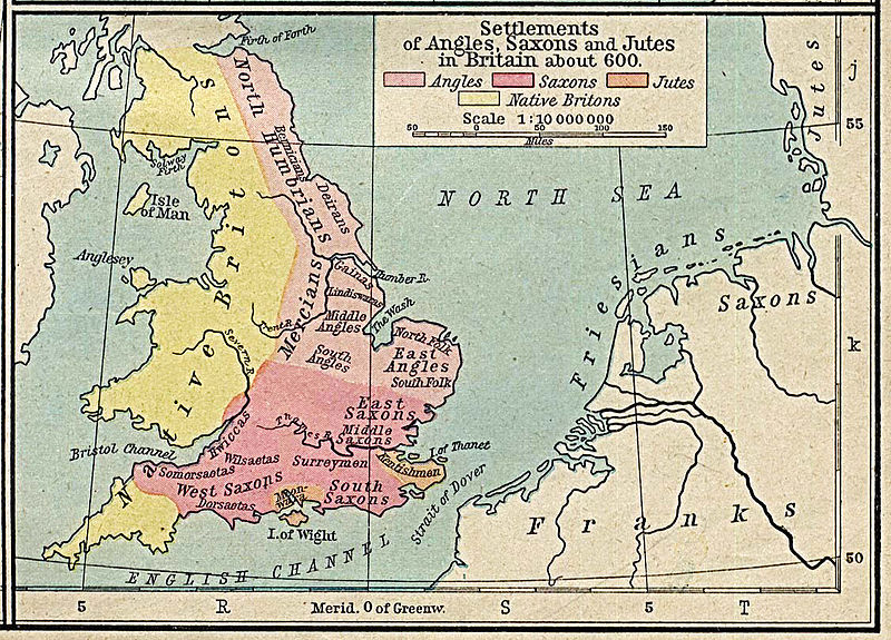
es: Mapa de Gran Bretaña en el año 600, con la correspondiente distribución de los pueblos Anglos, Sajones y Jutos.
Autorización del autor: Unless marked otherwise, the maps scanned by the University of Texas Libraries are in the public domain. The map images are not copyrighted and no permission is needed to copy them. You may download them and use them as you wish.
We do appreciate hearing from you about your use of these materials and we also appreciate you giving this site credit. Appropriate credit for public domain materials would be: "Courtesy of the University of Texas Libraries, The University of Texas at Austin."
For more information, see The PCL Map Collection Frequently Asked Questions page at http://www.lib.utexas.edu/maps/faq.html or feel free to contact me. __ Becky Schaefer Digital Library Services Division University of Texas Libraries
rschaefer@austin.utexas.edu
Licensing, updated
|
Aquest material està en domini públic als Estats Units i als altres països on el dret d'autor s'estén per 70 anys (o menys) després de la mort de l'autor.
| |
| Aquest fitxer està identificat com a lliure de restriccions conegudes sota la llei de drets d'autor, inclosos els drets veïns. | |
Historial del fitxer
Cliqueu una data/hora per veure el fitxer tal com era aleshores.
| Data/hora | Miniatura | Dimensions | Usuari/a | Comentari | |
|---|---|---|---|---|---|
| actual | 20:21, 17 abr 2013 | | 1.126 × 810 (301 Ko) | Hohum | Levels |
| 19:26, 18 abr 2006 |  | 1.126 × 810 (230 Ko) | Alexquendi~commonswiki | es: Mapa de Gran Bretaña en el año 600, con la correspondiente distribución de los pueblos Anglos, Sajones y Jutos. Autorización del autor: Unless marked otherwise, the maps scanned by the University of Texas Libraries are in the public domain. The m |
Ús del fitxer
Les 2 pàgines següents utilitzen aquest fitxer:
Ús global del fitxer
Utilització d'aquest fitxer en altres wikis:
- Utilització a arz.wikipedia.org
- Utilització a ast.wikipedia.org
- Utilització a br.wikipedia.org
- Utilització a de.wikipedia.org
- Utilització a en.wikipedia.org
- Utilització a es.wikipedia.org
- Utilització a he.wikipedia.org
- Utilització a it.wikipedia.org
- Utilització a nl.wikipedia.org
- Utilització a sv.wikipedia.org
- Utilització a uk.wikipedia.org
- Utilització a vls.wikipedia.org