
Fitxer:Aras River, Turkey-Armenia-Iran Border Region.JPG

Fitxer original (4.288 × 2.848 píxels, mida del fitxer: 13,14 Mo, tipus MIME: image/jpeg)
| Aquest fitxer i la informació mostrada a continuació provenen del dipòsit multimèdia lliure Wikimedia Commons. |
Resum
| Descripció |
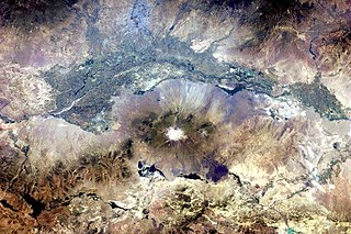
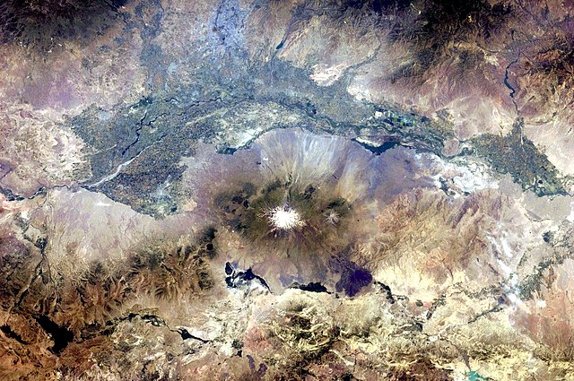
English: This astronaut photograph, taken from the International Space Station, highlights a segment of the international border between Armenia and Turkey. The Aras River separates the two countries, with Armenia to the north-north-east and Turkey to the south-south-west. Extensive green agricultural fields are common on both sides of the river (upper part of image), as well as a number of gray-to-tan urban areas including Yerevan (image top, slightly left of centre) and Artashat and Armavir in Armenia, and Iğdır in Turkey. While there have been efforts to normalize diplomatic relations between the two countries in recent years, the Armenia-Turkey border remains officially closed.
The dominant geographic feature in the region is Mt. Ararat, also known as Agri Dagi. The peak of Ararat, a large stratovolcano that last erupted in 1840 according to historical records, is located approximately 40 kilometres to the south of the Armenia-Turkey border. A lower peak to the east, known as Lesser or Little Ararat, is also volcanic in origin. Dark gray lava flows to the south of Mt. Ararat are located near the Turkish border with Iran. While this border is also closed along much of its length, official crossing points allow relatively easy travel between the two countries. The white, glacier-clad peak of Mt. Ararat is evident at image centre; dark green areas on the lower slopes indicate where vegetation cover is abundant. A large lake, Balik Golu or Fish Lake, is visible to the west (image lower left). |
| Data | |
| Font | NASA Earth Observatory |
| Autor | ISS Expedition 28 crew |
| Posició de la càmera | | Aquesta i altres imatges properes a: OpenStreetMap |
|---|
Aquest fitxer ha estat catalogat per Johnson Space Center dels Estats Units d'Amèrica per a l'Administració Nacional d'Aeronàutica i de l'Espai (NASA)en virtut identificat com a: ID del fitxer : ISS028-E-15023.Els ID dels fitxers i ID alternatius són traduïts de Photo ID .Aquesta etiqueta no indica l'estat dels drets d'autor de la imatge carregada. Cal un senyal de drets d'autor. Vegeu Commons:Sobre les llicències. Altres idiomes:
|
Image acquired with a Nikon D2Xs digital camera using a 65 mm lens, and is provided by the ISS Crew Earth Observations experiment and Image Science & Analysis Laboratory, Johnson Space Center.
Llicència
| Aquest fitxer és en el domini públic perquè ha estat creat per la NASA. L'avís legal de la NASA diu que «el material de la NASA no està protegit per copyright si no es diu el contrari». (NASA copyright policy page o JPL Image Use Policy). | ||
 |
Atenció:
|
| Anotacions | Aquesta imatge té anotacions: Vegeu-les a Commons |
Historial del fitxer
Cliqueu una data/hora per veure el fitxer tal com era aleshores.
| Data/hora | Miniatura | Dimensions | Usuari/a | Comentari | |
|---|---|---|---|---|---|
| actual | 20:37, 25 jul 2011 | | 4.288 × 2.848 (13,14 Mo) | Originalwana | {{Information |Description ={{en|1=This astronaut photograph, taken from the International Space Station, highlights a segment of the international border between Armenia and Turkey. The Aras River separates the two countries, with Armenia |
Ús del fitxer
Les 2 pàgines següents utilitzen aquest fitxer:
Ús global del fitxer
Utilització d'aquest fitxer en altres wikis:
- Utilització a af.wikipedia.org
- Utilització a ar.wikipedia.org
- Utilització a ast.wikipedia.org
- Utilització a avk.wikipedia.org
- Utilització a bn.wikipedia.org
- Utilització a en.wikipedia.org
- Utilització a es.wikipedia.org
- Utilització a fa.wikipedia.org
- Utilització a fi.wikipedia.org
- Utilització a gl.wikipedia.org
- Utilització a hsb.wikipedia.org
- Utilització a hy.wikipedia.org
- Utilització a hyw.wikipedia.org
- Utilització a it.wikipedia.org
- Utilització a ja.wikipedia.org
- Utilització a ka.wikipedia.org
- Utilització a ku.wikipedia.org
- Utilització a ml.wikipedia.org
- Utilització a pt.wikipedia.org
- Utilització a ro.wikipedia.org
- Utilització a ru.wikipedia.org
- Utilització a sk.wikipedia.org
- Utilització a sl.wikipedia.org
- Utilització a sv.wikipedia.org
- Utilització a tr.wikipedia.org
- Utilització a ur.wikipedia.org
- Utilització a uz.wikipedia.org