
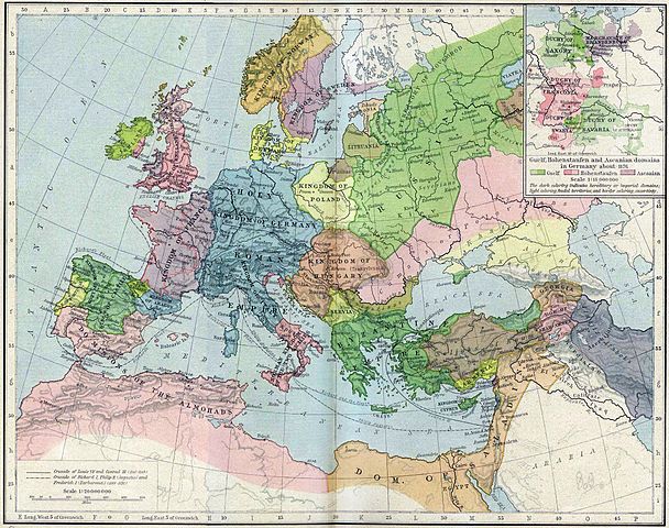
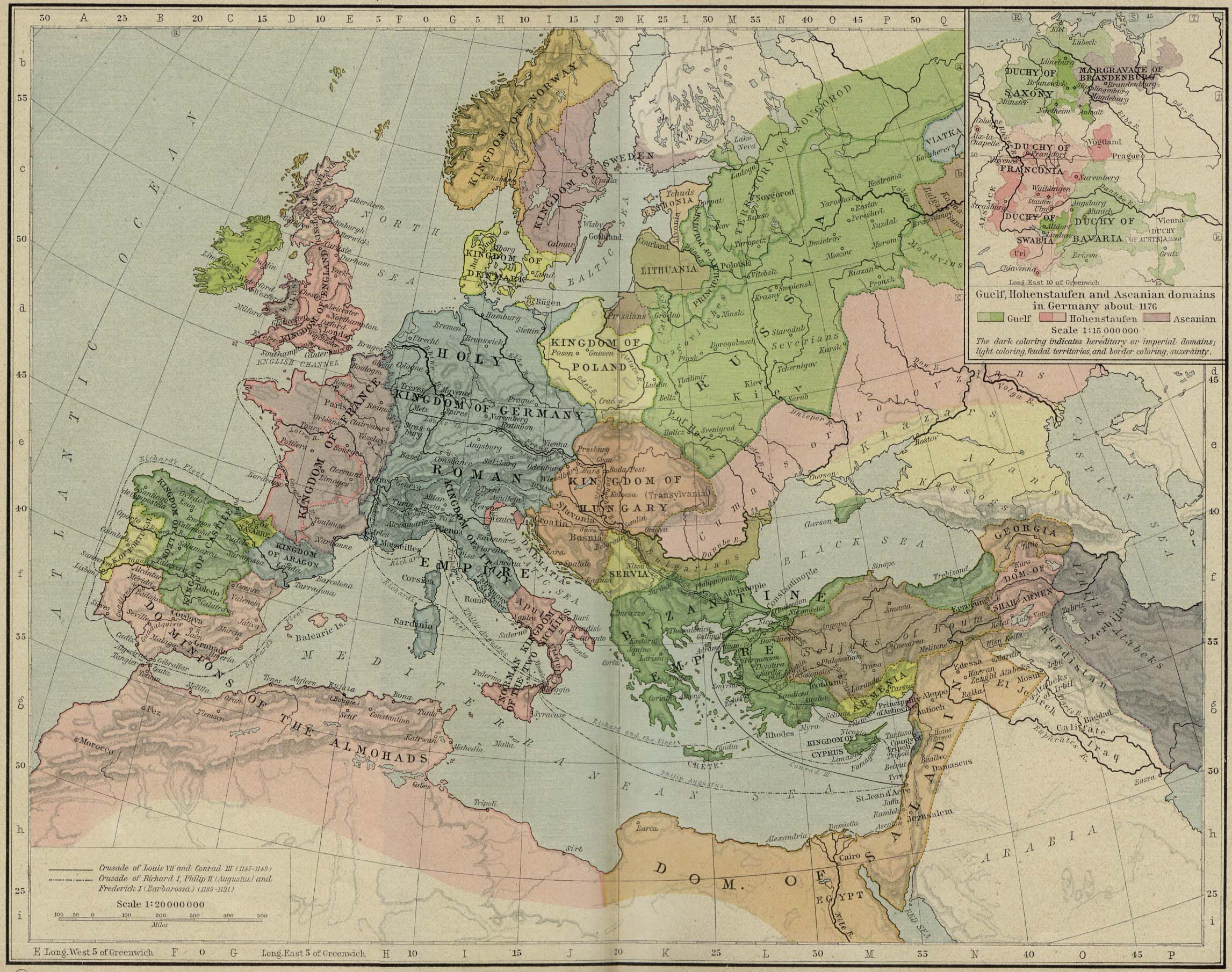
Fitxer:Europe mediterranean 1190.jpg

Mida d'aquesta previsualització: 760 × 600 píxels. Altres resolucions: 304 × 240 píxels | 608 × 480 píxels | 973 × 768 píxels | 1.280 × 1.010 píxels | 2.293 × 1.810 píxels.
Fitxer original (2.293 × 1.810 píxels, mida del fitxer: 834 Ko, tipus MIME: image/jpeg)
| Aquest fitxer i la informació mostrada a continuació provenen del dipòsit multimèdia lliure Wikimedia Commons. |
Resum
| Descripció | Europa en 1190. |
| Data | |
| Font | Perry-Castañeda Library, Map Collection: From the "Historical Atlas" by William R. Shepherd, New York, Henry Holt and Company, 1923 |
| Autor | Roke |
| Altres versions | العربيَّة |
.jpg)
.jpg)
_en.png)
.png)
.jpg)
Llicència
|
Aquest material està en domini públic als Estats Units i als altres països on el dret d'autor s'estén per 70 anys (o menys) després de la mort de l'autor. Aquesta obra es troba en el domini públic als Estats Units d'Amèrica per haver estat publicada abans de l'1 de gener de 1929. | |
| Aquest fitxer està identificat com a lliure de restriccions conegudes sota la llei de drets d'autor, inclosos els drets veïns. | |
Historial del fitxer
Cliqueu una data/hora per veure el fitxer tal com era aleshores.
| Data/hora | Miniatura | Dimensions | Usuari/a | Comentari | |
|---|---|---|---|---|---|
| actual | 17:46, 28 maig 2011 | | 2.293 × 1.810 (834 Ko) | Reddi~commonswiki | |
| 12:30, 8 maig 2006 |  | 2.293 × 1.810 (667 Ko) | Roke~commonswiki | Europe in 1190 {{Europe}} {{PD-PCL|http://www.lib.utexas.edu/maps/historical/shepherd/europe_mediterranean_1190.jpg}} Category: Historical maps of Europe |
Ús del fitxer
Les 7 pàgines següents utilitzen aquest fitxer:
Ús global del fitxer
Utilització d'aquest fitxer en altres wikis:
- Utilització a azb.wikipedia.org
- Utilització a az.wikipedia.org
- Utilització a cs.wikipedia.org
- Utilització a cy.wikipedia.org
- Utilització a da.wikipedia.org
- Utilització a de.wikipedia.org
- Utilització a el.wikipedia.org
- Utilització a en.wikipedia.org
- Utilització a en.wikibooks.org
- Utilització a eo.wikipedia.org
- Utilització a es.wikipedia.org
- Utilització a et.wikipedia.org
- Utilització a fa.wikipedia.org
- Utilització a fr.wikipedia.org
- Utilització a hr.wikipedia.org
- Utilització a hu.wikipedia.org
Vegeu més usos globals d'aquest fitxer.