
Fitxer:Map of Saint-Petersburg in 1720 (Homann).jpg

Fitxer original (1.476 × 1.264 píxels, mida del fitxer: 740 Ko, tipus MIME: image/jpeg)
| Aquest fitxer i la informació mostrada a continuació provenen del dipòsit multimèdia lliure Wikimedia Commons. |
| Descripció |
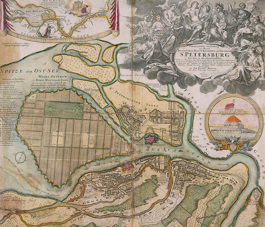
Português: Mapa de São Petersburgo. Gravura pintada sob aquarela, 50.5x59.5 cm. Datada da década de 1720 (antes de 1725)
English: Map of Saint-Petersburg. , Etching with line engraving, painted in watercolour, 50.5x59.5 cm. 1720s (before 1725)
Русский: План Санкт-Петербурга И. Хоманна. Бумага, офорт, резец, акварель. 50.5х59.5 см. 1720-е (до 1725)
Deutsch: Johann Baptist Homann (1664–1724): Topographische Vorstellung der Neuen Russischen Haupt-Residenz und See-Stadt St. Petersburg samt ihrer zu erst aufgerichteten Vestung: welche von Ihro Czaar Maj. Petro Alexiewitz aller Russen Selbst Erhalter etc., etc., etc. An. 1703 an der Spitze der Ost-See auf etlichen Insuln bey dem Außfluss des Neva Stroms erbaut und zur Aufnahm der Handelsschafft und Schiffarth für die Russische Nation mit einer mächtigen Flotte versehen worden herausgegeben von Ioh. Baptist Homann, Der Röm. Kays. Maj. Geographo, Nürnberg [zwischen 1719 und 1723]
Eine der frühesten Darstellungen Sankt Petersburgs. Die Nebenkarte in der linken oberen Ecke zeigt die Lage der Stadt an der Mündung des Flusses Newa. Der Newski Prospect, die heutige Prachtstraße St. Petersburgs, befand sich zur Zeit der Herstellung der Karte noch in Planung.
|
|||||||||||||||||||||||
| Data | entre 1719 i 1723 | |||||||||||||||||||||||
| Font | small ver., large ver. | |||||||||||||||||||||||
| Autor |
|
|||||||||||||||||||||||
| Permís (Com reutilitzar aquest fitxer) |
|
|||||||||||||||||||||||
| Altres versions |
Derivative works of this file: Map of Saint-Petersburg in 1720 (Homann) corner Nevskiy and Fontanka.jpg  |
|||||||||||||||||||||||
.jpg)
.jpg?uselang=ca)
_corner_Nevskiy_and_Fontanka.jpg)
Historial del fitxer
Cliqueu una data/hora per veure el fitxer tal com era aleshores.
| Data/hora | Miniatura | Dimensions | Usuari/a | Comentari | |
|---|---|---|---|---|---|
| actual | 19:40, 25 maig 2009 | | 1.476 × 1.264 (740 Ko) | Kaganer | large size |
| 14:31, 5 abr 2009 |  | 549 × 470 (78 Ko) | AndreyA | {{Information |Description={{En|Map of Saint-Petersburg in 1720}}{{En|План Санкт-Петербурга И. Хоманна.1720}} |Source=[http://www.encspb.ru/image.php?file=big%2f2803983508.jpg Энциклопедия Санкт-Петербур |
Ús del fitxer
La pàgina següent utilitza aquest fitxer:
Ús global del fitxer
Utilització d'aquest fitxer en altres wikis:
- Utilització a azb.wikipedia.org
- Utilització a ba.wikipedia.org
- Utilització a bg.wikipedia.org
- Utilització a bxr.wikipedia.org
- Utilització a de.wikipedia.org
- Utilització a en.wikipedia.org
- Utilització a fr.wikipedia.org
- Utilització a he.wikipedia.org
- Utilització a hy.wikipedia.org
- Utilització a hyw.wikipedia.org
- Utilització a ka.wikipedia.org
- Utilització a ru.wikipedia.org
- Utilització a uk.wikipedia.org
.jpg)