
Fitxer:Mappa storica A8.svg

Mida d'aquesta previsualització PNG del fitxer SVG: 800 × 566 píxels. Altres resolucions: 320 × 226 píxels | 640 × 453 píxels | 1.024 × 724 píxels | 1.280 × 905 píxels | 2.560 × 1.810 píxels | 1.052 × 744 píxels.
Fitxer original (fitxer SVG, nominalment 1.052 × 744 píxels, mida del fitxer: 48 Ko)
| Aquest fitxer i la informació mostrada a continuació provenen del dipòsit multimèdia lliure Wikimedia Commons. |
Resum
| Descripció |
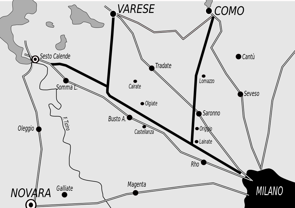
English: Historical map of the original A8 motorway, Italy
Italiano: Mappa storica dell'originale percorso dell'A8 |
| Data | |
| Font | Treball propi |
| Autor | Gigillo83 |
Llicència
Jo, el titular dels drets d'autor d'aquest treball, el public sota les següents llicències:
Aquest fitxer està subjecte a la llicència de Creative Commons Reconeixement i Compartir Igual 3.0 No adaptada.
- Sou lliure de:
- compartir – copiar, distribuir i comunicar públicament l'obra
- adaptar – fer-ne obres derivades
- Amb les condicions següents:
- reconeixement – Heu de donar la informació adequada sobre l'autor, proporcionar un enllaç a la llicència i indicar si s'han realitzat canvis. Podeu fer-ho amb qualsevol mitjà raonable, però de cap manera no suggereixi que l'autor us dóna suport o aprova l'ús que en feu.
- compartir igual – Si modifiqueu, transformeu, o generareu amb el material, haureu de distribuir les vostres contribucions sota una llicència similar o una de compatible com l'original

|
S'autoritza la còpia, la distribució i la modificació d'aquest document sota els termes de la llicència de documentació lliure GNU versió 1.2 o qualsevol altra versió posterior que publiqui la Free Software Foundation; sense seccions invariants, ni textos de portada, ni textos de contraportada. S'inclou una còpia d'aquesta llicència en la secció titulada GNU Free Documentation License. |
Podeu seleccionar la llicència que vulgueu.
Historial del fitxer
Cliqueu una data/hora per veure el fitxer tal com era aleshores.
| Data/hora | Miniatura | Dimensions | Usuari/a | Comentari | |
|---|---|---|---|---|---|
| actual | 20:59, 24 set 2009 | | 1.052 × 744 (48 Ko) | Gigillo83 | Inserimento nomi località |
| 20:47, 24 set 2009 |  | 1.052 × 744 (51 Ko) | Gigillo83 | {{Information |Description={{en|1=Historical map of the original A8 motorway, Italy}} {{it|1=Mappa storica dell'originale percorso dell'A8}} |Source=Own work by uploader |Author=Gigillo83 |Date=24/09/2009 |Permission= |other_versions= } |
Ús del fitxer
La pàgina següent utilitza aquest fitxer:
Ús global del fitxer
Utilització d'aquest fitxer en altres wikis:
- Utilització a de.wikipedia.org
- Utilització a en.wikipedia.org
- Utilització a fr.wikipedia.org
- Utilització a it.wikipedia.org
- Utilització a ja.wikipedia.org
- Utilització a lmo.wikipedia.org
- Utilització a ms.wikipedia.org
- Utilització a nl.wikipedia.org
- Utilització a pt.wikipedia.org
- Utilització a ro.wikipedia.org
- Utilització a ru.wikipedia.org
- Utilització a sk.wikipedia.org
- Utilització a sr.wikipedia.org
- Utilització a sv.wikipedia.org
- Utilització a th.wikipedia.org
- Utilització a uk.wikipedia.org
- Utilització a vi.wikipedia.org