
Fitxer:PresqueIsleStatePark.JPG

Mida d'aquesta previsualització: 800 × 517 píxels. Altres resolucions: 320 × 207 píxels | 640 × 413 píxels | 1.024 × 661 píxels | 1.280 × 827 píxels | 2.871 × 1.854 píxels.
Fitxer original (2.871 × 1.854 píxels, mida del fitxer: 767 Ko, tipus MIME: image/jpeg)
| Aquest fitxer i la informació mostrada a continuació provenen del dipòsit multimèdia lliure Wikimedia Commons. |
Resum
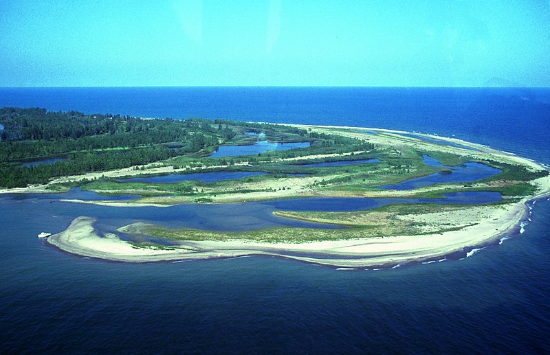
| Descripció | Aerial view of w:Presque Isle State Park, w:Erie, Pennsylvania. The photo is taken from the northeast and shows Gull Point in the foreground. Photo has some problems because of scanning. |
| Data | Data desconeguda |
| Font | http://www.fhwa.dot.gov/byways/photos/59490 |
| Autor | Robert K. Grubbs; cleaned up and color-corrected by Howcheng |
| Permís (Com reutilitzar aquest fitxer) |
Released to public domain when submitted to the FHWA with 2005 nomination application. |
| Altres versions | Original sample available at source URL. |
| Posició de la càmera | | Aquesta i altres imatges properes a: OpenStreetMap |
|---|
Llicència
| S'ha alliberat aquesta obra al domini públic pel seu autor Robert K. Grubbs. Això s'aplica a tot el món. En alguns països això pot no ser legalment possible, en tal cas: Robert K. Grubbs concedeix a tothom el dret d'usar aquesta obra per a qualsevol propòsit, sense cap condició llevat d'aquelles requerides per la llei.
|
Historial del fitxer
Cliqueu una data/hora per veure el fitxer tal com era aleshores.
| Data/hora | Miniatura | Dimensions | Usuari/a | Comentari | |
|---|---|---|---|---|---|
| actual | 19:47, 21 abr 2006 | | 2.871 × 1.854 (767 Ko) | Holly Cheng | ==Summary== {{Information | Description=Aerial view of w:Presque Isle State Park, w:Erie, Pennsylvania. The photo is taken from the northeast and shows Gull Point in the foreground. Photo has some problems because of scanning. | Source=http://libr |
Ús del fitxer
La pàgina següent utilitza aquest fitxer:
Ús global del fitxer
Utilització d'aquest fitxer en altres wikis:
- Utilització a en.wikipedia.org
- Lake Erie
- List of Pennsylvania state parks
- Presque Isle State Park
- User talk:Pnoble805
- User talk:Tomdonohue1
- User talk:Trey/archive A
- User:SandyGeorgia/Barnstars
- User talk:Niagara/Archive 2
- User:Trey/Barnstars
- User talk:VerruckteDan/Archive6
- User talk:TomStar81/Archive 4
- User talk:SandyGeorgia/arch23
- User:Gerry D/archive6
- User talk:Michael Devore/Archive 1
- User talk:Finetooth/Archive 1
- User talk:Dwarf Kirlston/FAC Archive
- User talk:YellowMonkey/Archive67
- Wikipedia:Today's featured article/November 2017
- Wikipedia:Today's featured article/November 18, 2017
- Wikipedia:Main Page history/2017 November 18
- Utilització a fr.wikipedia.org
- Utilització a pl.wikipedia.org
- Utilització a qu.wikipedia.org
- Utilització a zh.wikipedia.org