
Fitxer:Taklimakanm.jpg

Mida d'aquesta previsualització: 800 × 600 píxels. Altres resolucions: 320 × 240 píxels | 640 × 480 píxels | 1.024 × 768 píxels | 1.280 × 960 píxels | 2.560 × 1.920 píxels | 4.800 × 3.600 píxels.
Fitxer original (4.800 × 3.600 píxels, mida del fitxer: 2,79 Mo, tipus MIME: image/jpeg)
| Aquest fitxer i la informació mostrada a continuació provenen del dipòsit multimèdia lliure Wikimedia Commons. |
Resum
| Descripció |
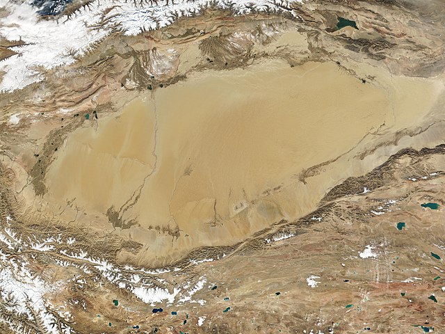
English: The Taklamakan Desert in northwest China is a vast region of sand desert sitting in a depression between two high, rugged mountain ranges. Seen in this true-color MODIS image from October 27, 2001, the Taklimakan's rolling sand dunes stretch out over several hundred thousand square miles in the Xinjiang region of China. The desert is hemmed in to the north by the snow-covered Tien Shan Mountain range and to the south by the rugged Kunlun Mountains. At the lower left corner of the image is the Karakoram Mountain range, where the world's second highest mountain, K2, casts a blue shadow (see high-resolution image for an up-close look). Desertification and shifting sand dunes are a major concern for the farmers and herders who live at the Taklimakan's edge. At the bottom of the image lies the Tibetan Plateau. |
| Data | Taken on 27 d'octubre de 2001 |
| Font | http://www.gsfc.nasa.gov/indepth/photos_earth2001_p1.html (archive) |
| Autor | NASA/GSFC/MODIS Team |
Llicència
| Aquest fitxer és en el domini públic perquè ha estat creat per la NASA. L'avís legal de la NASA diu que «el material de la NASA no està protegit per copyright si no es diu el contrari». (NASA copyright policy page o JPL Image Use Policy). | ||
 |
Atenció:
|
Historial del fitxer
Cliqueu una data/hora per veure el fitxer tal com era aleshores.
| Data/hora | Miniatura | Dimensions | Usuari/a | Comentari | |
|---|---|---|---|---|---|
| actual | 04:05, 27 set 2020 | | 4.800 × 3.600 (2,79 Mo) | Huntster | 250m resolution version. |
| 23:33, 23 ago 2005 |  | 1.200 × 900 (324 Ko) | Nanosmile | Description: The Taklimakan Desert in northwest China is a vast region of sand desert sitting in a depression between two high, rugged mountain ranges. Seen in this true-color MODIS image from October 27, 2001, the Taklimakan's rolling sand dunes stretch |
Ús del fitxer
La pàgina següent utilitza aquest fitxer:
Ús global del fitxer
Utilització d'aquest fitxer en altres wikis:
- Utilització a af.wikipedia.org
- Utilització a als.wikipedia.org
- Utilització a bn.wikipedia.org
- Utilització a br.wikipedia.org
- Utilització a de.wikipedia.org
- Utilització a en.wikipedia.org
- Utilització a eo.wikipedia.org
- Utilització a es.wikipedia.org
- Utilització a et.wikipedia.org
- Utilització a eu.wikipedia.org
- Utilització a fa.wikipedia.org
- Utilització a fi.wikipedia.org
- Utilització a fr.wikipedia.org
- Utilització a gl.wikipedia.org
- Utilització a he.wikipedia.org
- Utilització a hu.wikipedia.org
- Utilització a hy.wikipedia.org
- Utilització a id.wikipedia.org
- Utilització a it.wikipedia.org
- Utilització a ku.wikipedia.org
- Utilització a ky.wikipedia.org
- Utilització a nds.wikipedia.org
- Utilització a nn.wikipedia.org
- Utilització a no.wikipedia.org
- Utilització a pt.wikipedia.org
- Utilització a ro.wikipedia.org
- Utilització a ru.wikipedia.org
- Utilització a sr.wikipedia.org
- Utilització a th.wikipedia.org
- Utilització a tr.wikipedia.org
Vegeu més usos globals d'aquest fitxer.