
Fitxer:High Water Mark - Cemetery Ridge, Gettysburg Battlefield.jpg
High_Water_Mark_-_Cemetery_Ridge,_Gettysburg_Battlefield.jpg (528 × 352 píxels, mida del fitxer: 45 Ko, tipus MIME: image/jpeg)
| Aquest fitxer i la informació mostrada a continuació provenen del dipòsit multimèdia lliure Wikimedia Commons. |
Resum
| Descripció |
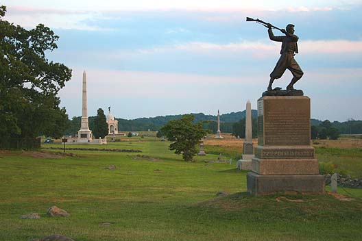
English: "High Water Mark" - Cemetery Ridge, Gettysburg Battlefield
This photo shows the so-called "High Water Mark" as it appears today. This is the location on Cemetery Ridge where the Confederate Army attacked the center of the Union lines on the 3rd day of the Battle of Gettysburg. Although this attack has been popularly known as "Pickett's Charge" it in fact was executed by three Confederate divisions, commanded by Major Generals George Pickett, J. Johnston Pettigrew, and Isaac R. Trimble, consisting of troops from Gen. James Longstreet's First Corps and A.P. Hill's Third Corps. This photo looks south along the Ridge with Little Round Top and Big Round Top in the distant background. The monument in the front is the 72nd Pennsylvania Infantry Monument. |
| Data |
Sculpture:1888, dedicated July 4, 1891.[1] Photo:2005 |
| Font | Originally uploaded as en:Image:3698.jpg on August 27, 2005 by the photographer, then moved at the Commons from Image:3698.jpg to here. Move approved by User:Dgies. |
| Autor |
Sculpture: signed Stephens. Photo: Robert Swanson (en:User:Ryssby) |
| Posició de la càmera | | Aquesta i altres imatges properes a: OpenStreetMap |
|---|
Image history at en: (del) (cur) 01:26, 27 August 2005 . . Ryssby . . 564x392 (54055 bytes) (The so-called "high water mark" as it appears today. The is the location where the Confederates made their furtherest thrust north, which in this case was Cemetery Ridge, Gettysburg. )
Llicència
Photo:

|
S'autoritza la còpia, la distribució i la modificació d'aquest document sota els termes de la llicència de documentació lliure GNU versió 1.2 o qualsevol altra versió posterior que publiqui la Free Software Foundation; sense seccions invariants, ni textos de portada, ni textos de contraportada. S'inclou una còpia d'aquesta llicència en la secció titulada GNU Free Documentation License. |
| Aquest fitxer està subjecte a la llicència de Creative Commons Reconeixement i Compartir Igual 3.0 No adaptada. | ||
| ||
| Aquest avís de llicència s'ha afegit a aquest fitxer d'acord amb l'actualització de la llicència GFDL. |
Sculpture:
This work is in the public domain in the United States because it was published (or registered with the U.S. Copyright Office) before January 1, 1929.
Public domain works must be out of copyright in both the United States and in the source country of the work in order to be hosted on the Commons. If the work is not a U.S. work, the file must have an additional copyright tag indicating the copyright status in the source country.
Note: This tag should not be used for sound recordings. |
File histhhory
| date/time | username | resolution | size | edit summary |
|---|---|---|---|---|
| 11:39, 2 April 2007 | User:Editor at Large | 528×352 | 45 KB | <span class="comment">(Losslessly cropped border)</span> |
| 15:44, 27 November 2005 | User:Edmund Ferman | 564×392 | 53 KB |
Historial del fitxer
Cliqueu una data/hora per veure el fitxer tal com era aleshores.
| Data/hora | Miniatura | Dimensions | Usuari/a | Comentari | |
|---|---|---|---|---|---|
| actual | 04:06, 21 abr 2008 | | 528 × 352 (45 Ko) | BetacommandBot | move approved by: User:Dgies This image was moved from Image:3698.jpg ==Summary== '''Caption read:''' "High Water Mark" - Cemetery Ridge, Gettysburg Battlefield This photo shows the so-called "High Water Mark" as it appears today. This is the |
Ús del fitxer
La pàgina següent utilitza aquest fitxer:
Ús global del fitxer
Utilització d'aquest fitxer en altres wikis:
- Utilització a azb.wikipedia.org
- Utilització a bg.wikipedia.org
- Utilització a cs.wikipedia.org
- Utilització a da.wikipedia.org
- Utilització a de.wikipedia.org
- Utilització a en.wikipedia.org
- Utilització a en.wikiquote.org
- Utilització a es.wikipedia.org
- Utilització a fr.wikipedia.org
- Utilització a he.wikipedia.org
- Utilització a it.wikipedia.org
- Utilització a ja.wikipedia.org
- Utilització a ko.wikipedia.org
- Utilització a no.wikipedia.org
- Utilització a pl.wikipedia.org
- Utilització a pt.wikipedia.org
- Utilització a ru.wikipedia.org
- Utilització a sr.wikipedia.org
- Utilització a sv.wikipedia.org
- Utilització a www.wikidata.org
- Utilització a zh.wikipedia.org