
Fitxer:London Underground Overground DLR Crossrail map.svg

Mida d'aquesta previsualització PNG del fitxer SVG: 800 × 422 píxels. Altres resolucions: 320 × 169 píxels | 640 × 338 píxels | 1.024 × 541 píxels | 1.280 × 676 píxels | 2.560 × 1.352 píxels | 2.500 × 1.320 píxels.
Fitxer original (Fitxer SVG animat, nominalment 2.500 × 1.320 píxels, mida del fitxer: 219 Ko)
Nota: per limitacions tècniques no s'animaran les miniatures per aquest fitxer.
| Aquest fitxer i la informació mostrada a continuació provenen del dipòsit multimèdia lliure Wikimedia Commons. |
Resum
| Descripció |
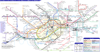
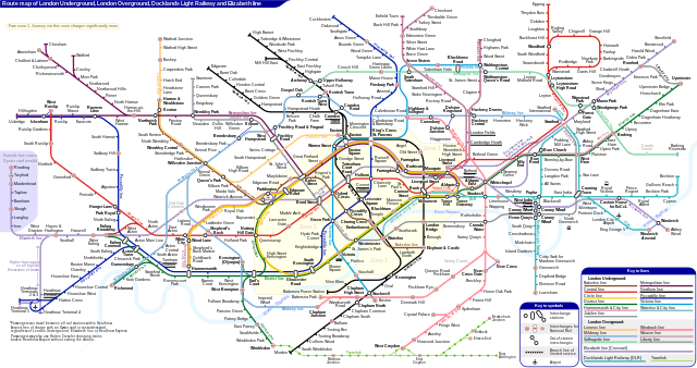
English: *Route map of London Underground, London Overground, Docklands Light Railway and Elizabeth line (Crossrail), including most green-lighted proposals.
|
|||
| Data | ||||
| Font | Treball propi | |||
| Autor | Sameboat | |||
| Permís (Com reutilitzar aquest fitxer) |
Jo, el titular dels drets d'autor d'aquest treball, el public sota la següent llicència: This file is licensed under the Creative Commons Attribution-Share Alike 4.0 International license.
|
|||
| Altres versions |
|
|||
| SVG genesis | Aquesta imatge vectorial ha estat creada amb unknown tool This icon uses embedded text that can be easily translated using a text editor. |


|
Aquest és un fitxer SVG animat que utilitza SMIL. La previsualització PNG de més amunt creada amb librsvg no és animada i pot ser incompleta o incorrecta. Per veure bé l'animació obriu media:London Underground Overground DLR Crossrail map.svg amb un navegador o visualitzador que admeti animacions SVG, com Opera (8+), Safari (4+), Chrome (2+) o Internet Explorer amb Adobe SVG viewer instal·lat. Firefox do admet SMIL fins a la versió 3.5. Es poden trobar altres animacions SVG a Category:Animated SVG files.
|

Historial del fitxer
Cliqueu una data/hora per veure el fitxer tal com era aleshores.
| Data/hora | Miniatura | Dimensions | Usuari/a | Comentari | |
|---|---|---|---|---|---|
| actual | 08:27, 25 març 2024 | | 2.500 × 1.320 (219 Ko) | Sameboat | change OOC icon to NR |
| 08:22, 23 març 2024 |  | 2.500 × 1.320 (219 Ko) | Sameboat | restore changes made by The wub and Jc86035 | |
| 08:17, 23 març 2024 |  | 2.500 × 1.320 (219 Ko) | Sameboat | + Old Oak Common | |
| 01:16, 20 març 2024 |  | 2.500 × 1.320 (219 Ko) | The wub | Update cable car, add tooltip for Woolwich/Woolwich Arsenal interchange | |
| 23:54, 19 feb 2024 |  | 2.500 × 1.320 (219 Ko) | Jc86035 | Wandsworth Road | |
| 03:09, 19 feb 2024 |  | 2.500 × 1.320 (219 Ko) | Sameboat | ||
| 16:42, 16 feb 2024 |  | 2.500 × 1.320 (219 Ko) | Sameboat | ||
| 16:37, 16 feb 2024 |  | 2.500 × 1.320 (219 Ko) | Sameboat | overground new names and new colors | |
| 08:03, 7 nov 2022 |  | 2.500 × 1.320 (221 Ko) | Sameboat | Pudding Mill Lane portal | |
| 07:19, 6 nov 2022 |  | 2.500 × 1.320 (224 Ko) | Sameboat | Elizabeth line thru Paddington |
Ús del fitxer
La pàgina següent utilitza aquest fitxer:
Ús global del fitxer
Utilització d'aquest fitxer en altres wikis:
- Utilització a af.wikipedia.org
- Utilització a ar.wikipedia.org
- Utilització a de.wikipedia.org
- Utilització a en.wikipedia.org
- Tube map
- Transport for London
- Schematic
- List of London Underground stations
- London Rail
- Wikipedia:Wikipedia Signpost/2015-06-03/In the media
- Wikipedia:Wikipedia Signpost/Single/2015-06-03
- User:Bellowhead678/sandbox
- Elizabeth line
- User:RogerNiceEyes/sandbox
- Talk:Elizabeth line
- Glossary of geography terms (N–Z)
- Utilització a en.wikivoyage.org
- Utilització a es.wikipedia.org
- Utilització a es.wikivoyage.org
- Utilització a fa.wikipedia.org
- Utilització a fi.wikipedia.org
- Utilització a fr.wikipedia.org
- Liste des stations du métro de Londres
- Woodside Park (métro de Londres)
- Gare de Moorgate
- High Barnet (métro de Londres)
- Totteridge & Whetstone (métro de Londres)
- Morden (métro de Londres)
- Burnt Oak (métro de Londres)
- West Finchley (métro de Londres)
- Brent Cross (métro de Londres)
- Golders Green (métro de Londres)
- Kensal Green (métro de Londres)
- Queen's Park (métro de Londres)
- Finchley Central (métro de Londres)
- Colliers Wood (métro de Londres)
- Mill Hill East (métro de Londres)
- Edgware (métro de Londres)
- Balham (métro de Londres)
- Barking (métro de Londres)
- Colindale (métro de Londres)
- Hendon Central (métro de Londres)
- Kilburn Park (métro de Londres)
- Kenton (métro de Londres)
Vegeu més usos globals d'aquest fitxer.